Sunday, October 28, 2007

San Diego Air Quality Data

The fires are out of the major San Diego metropolitan areas, but the air quality is still bad. The following link provides an hourly update on air pollution - including the 2.5 micron fire-generated particulate matter.

http://www.sdapcd.org/air/data/web_report.txt

There's alot of data there; look for the "11_PM_2_5 (UG/M3) heading. The data there provide an hourly reading on how much of the 2.5 micron fire-generated particles are still in the air. The ug/m3 means "micrograms per cubic meter".

Wednesday, October 24, 2007

The Counties of Southern California:


2007.10.25.06.00.negative.UTC.jpg


2007.10.25.05.30.negative.UTC.jpg


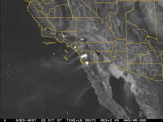
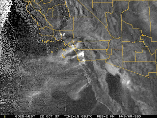
2007.10.24.15.00.visible.UTC.jpg


2007.10.24.15.00.UTC.jpg


2007.10.24.13.30.negative.UTC.jpg


2007.10.24.00.00.visible.UTC.jpg

2007.10.23.22.45.visible.UTC.jpg


2007.10.23.21.00UTC.jpg


2007.10.23.17.30UTC.jpg

2007.10.23.16.00UTC.negative.jpg


2007.10.23.15.00UTC.negative


2007.10.23.14.00UTC: Sunrise.

Google Earth kmz file Overlay

I noticed that the timestamps on the lat/lon points from the Google Earth kmz file were all the same (and stale); I believe that it can only be upadated when the satellite passes overhead (in a polar orbit?). The position data is only valid for infrequent snapshots of fire position.

Tuesday, October 23, 2007

A fire map overlay for Google Earth:

http://activefiremaps.fs.fed.us/kml/conus.kmz

Monday, October 22, 2007

5:00am UTC


3:30am UTC


2:00am UTC

23:00


22:00


21:00


20:30

Fire update (GMT times)

20:00


19:00


18:30

The last two hours

1800


1730


1700


1630


1600

kpbs.org has created a site utilizing Google Maps

http://tinyurl.com/37dvp2

Back to Fog View


I don't know what the "sunrise transient" was. But now, both the heat and the smoke plumes are visible.

From "Fog" View to "Visible" View


Now that the sun is up, the smoke plumes blowing west are visible.


The "hotspot" (fog) view is being swamped by the heat generated by sunrise.


The evacuation announcements cover over 60 square miles for the Witch fire alone. The agencies are begging the public to evacuate the areas bounded by I-15, I-5, Highway 56, and Del Dios Hwy.

The Harris fire continues


The Witch Creek fire in northern San Diego County appears to have doubled in size in the last 6 1/2 hours. Interstate I-15 has been closed between Escondido and Rancho Bernardo, and the evacuation orders continue for those in the path (west) of the fire.

The Santa Ana wind warnings are in effect throughout the day.

Sunday, October 21, 2007


(click on image for magnified view)
Here's a direct link to the NOAA / National Weather Service Satellite Image page for San Diego & Southern California. The Fog map shows the fire locations:

http://www.wrh.noaa.gov/sgx/sat/satellite.php

A map of the counties of Southern California.


Looks like the satellite image is updating every 30 minutes, but there's at least a half-hour lag.
This animated link (not sure how long it will last) shows the "Santa Ana" winds from the desert push the coastal moisture off shore; the Witch Creek fire in northern San Diego County can be seen flaring during the animation.

http://tinyurl.com/3c66d9

Satellite image of San Diego fires


I'm listening to the radio now, as the community of Ramona (San Diego County) is being evacuated. Ten thousand people are being ordered to evacuate now; I think that about 4K people have been evacuated from two regions in San Diego County in the last eight hours.

This image is a satellite feed from NOAA.